PESHAWAR: The Provincial Disaster Management Authority (PDMA) of Khyber Pakhtunkhwa has issued its latest urgent weather alert, warning of widespread heavy rainfall, severe hailstorms, and high-velocity winds set to sweep across the province from June 16.
PDMA’s Anwar Shehzad said that district administration teams across Chitral, Dir, Swat, Shangla, and Kohistan have been placed on high alert for sudden mountain landslides that could sever major transit arteries and isolate villages and communities in far valleys and on hillsides.
This latest downpour is only the final act in what has been a turbulent month of weather for the province.
In early June, the province experienced a severe heatwave, with temperatures in Peshawar, Mardan, and Dera Ismail Khan rising 4-6 degrees Celsius above seasonal averages, straining electrical grids and public health systems.
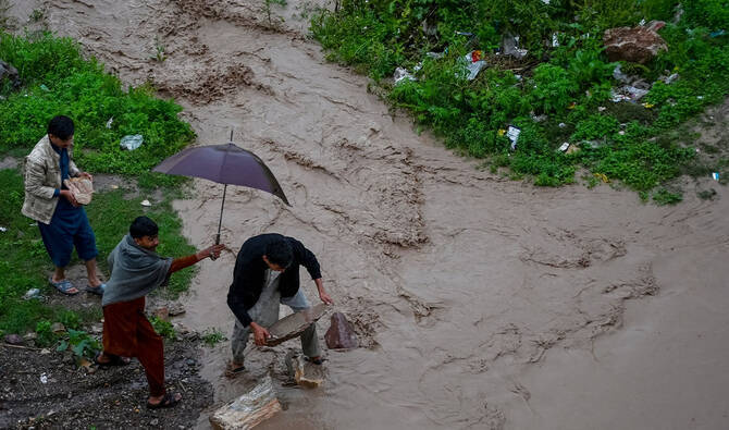
From June 11 to 13, rainstorms caused significant damage in Bannu, Shangla, and Mansehra, resulting in the deaths of nine people and injuries to 33 others due to roof collapses, flash floods, and electrocution.
Additionally, the extreme heat led to Glacial Lake Outburst Flood alerts by June 13, as high-altitude glaciers melted rapidly.
The sudden volume of water strained fragile, naturally occurring glacial dams, threatening to unleash torrents into downstream villages and communities.
Within days, this severe heat system collapsed into violent thunderstorms, windstorms and the current landslide-inducing rains.
Clash of macro-climate systems
The rapid succession from severe heat to icy glacial threats and violent rain and hailstorms has felt like a weather anomaly. However, atmospheric scientists view it as a recurring, textbook-level, highly volatile meteorological phenomenon.
According to Dr Fahim Anwar, a prominent regional meteorologist, the violent weather pattern is fundamentally driven by a clash of macro-climate systems.
“The phenomenon is caused by hot winds rolling off the Arabian Sea colliding directly with much cooler winds sweeping in from the Mediterranean, a system widely known as the westerly wave,” he said, speaking to Pakistan TV Digital.
When these cool Mediterranean currents override the superheated, low-pressure vacuum created by the early June heatwave, the atmosphere becomes unstable. The hot surface air rises rapidly, condensing into massive convective clouds that drop heavy rain and hail within hours.
The moisture moving up from the Arabian Sea acts as continuous fuel, feeding these localized storm cells.
Global warming is to blame, too
However, while the timing of these patterns aligns with the traditional pre-monsoon transition window, their ferocity is a different story. Dr Anwar emphasizes that global warming is actively hyper-charging these natural cycles.
"These weather patterns in themselves might seem weird, but they are somewhat normal for this time of the year," explains Dr Anwar. "Although global warming has severely increased the intensity of this phenomenon and will continue to do so for the next many years."
The long-term implications for Khyber Pakhtunkhwa are severe. Rising global temperatures mean that future heatwaves will be hotter, glacial melting will occur faster and earlier in the spring, and the resulting convective storms will carry far more destructive energy.
For a province known for its extreme geographic diversity -- spanning low plains to 7,000-meter peaks -- this intensity of climate change means the domino effect from heatwaves to landslides could increase, leaving disaster management authorities with much smaller windows to react.


.jpg)